Home > Blog > Widespread storm damage along the West Coast
Widespread storm damage along the West Coast
September 18, 2022
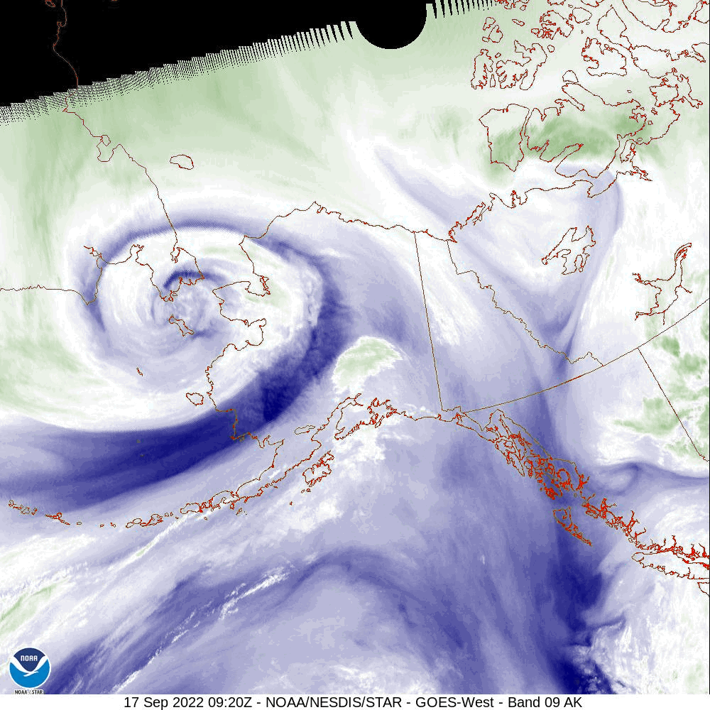
A powerful storm has caused severe and widespread damage along Alaska’s West Coast. As of early morning on Sunday, September 18, water levels are receding along the Bering coast but still rising along the Chukchi coast as ex-typhoon Merbok moves northwards.
Coastal communities all along the West Coast from the Kuskokwim delta to Norton Sound and the Bering Strait are reporting major flood and wind related damage. Residents were forced to evacuate their homes and shelter in schools or seek higher ground, e.g., in Golovin, Hooper Bay, and Newtok. Several homes have reportedly floated off their foundations. Flooding has led to extensive infrastructure damage including washed out roads, flooded air fields, inundated homes, and destroyed berms and boats. The severe storm has strongly accelerated coastal erosion in communities vulnerable to erosion. Newtok is particularly affected by this, with the riverbank reportedly eroding 10-20 feet overnight.
The effects of the storm are being felt as far inland as Bethel, where the Kuskokwim river caused minor flooding as ocean water was pushed up-river.
Ex-typhoon Merbok centered near the Bering Strait on Sep. 17. Water vapour satellite imagery (NOAA)
Strongest storm in decades
Merbok is one of the strongest September storms on record for the Northern Bering Sea. During the historic storm of November 2011, sea ice provided some protection for the coasts. This time, lacking ice cover, the full impacts of the storm are being felt in the coastal communities. Water levels in Nome are thought to have reached the highest level in about 50 years (since the 1974 flood), but the final tally of storm records is still out. As the storm moves into the Chukchi sea, northern coastal communities are bracing for impact.
Tropical storms such as Merbok are typically referred to as typhoons when they form in the Northwest Pacific, cyclones when they form in the Indian Ocean or South Pacific and Hurricanes when they form in the Atlantic. Despite the different naming conventions, the mechanisms of storm formation or cyclogenesis are the same. Tropical cyclones form over relatively warm ocean water and draw their energy from it. In contrast, the formation of mid-latitude, extratropical cyclones requires strong horizontal temperature gradients. Merbok is being referred to as an ex-typhoon because it began its journey as a tropical cyclone – a typhoon – but has now moved outside of the tropics. It has become to an extratropical storm in terms of location and in terms of the underlying processes driving the storm. As it moved north, Merbok transitioned from a tropical storm fuelled by the warm ocean to a mid-latitude storm that draws its energy from baroclinic processes (gradients in pressure and temperature).
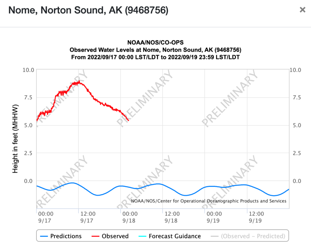
Water level peaked in nome around Noon on Sep. 17. (Red line is observed water level, blue line is normal tide level). Source: NOAA https://tidesandcurrents.noaa.gov/
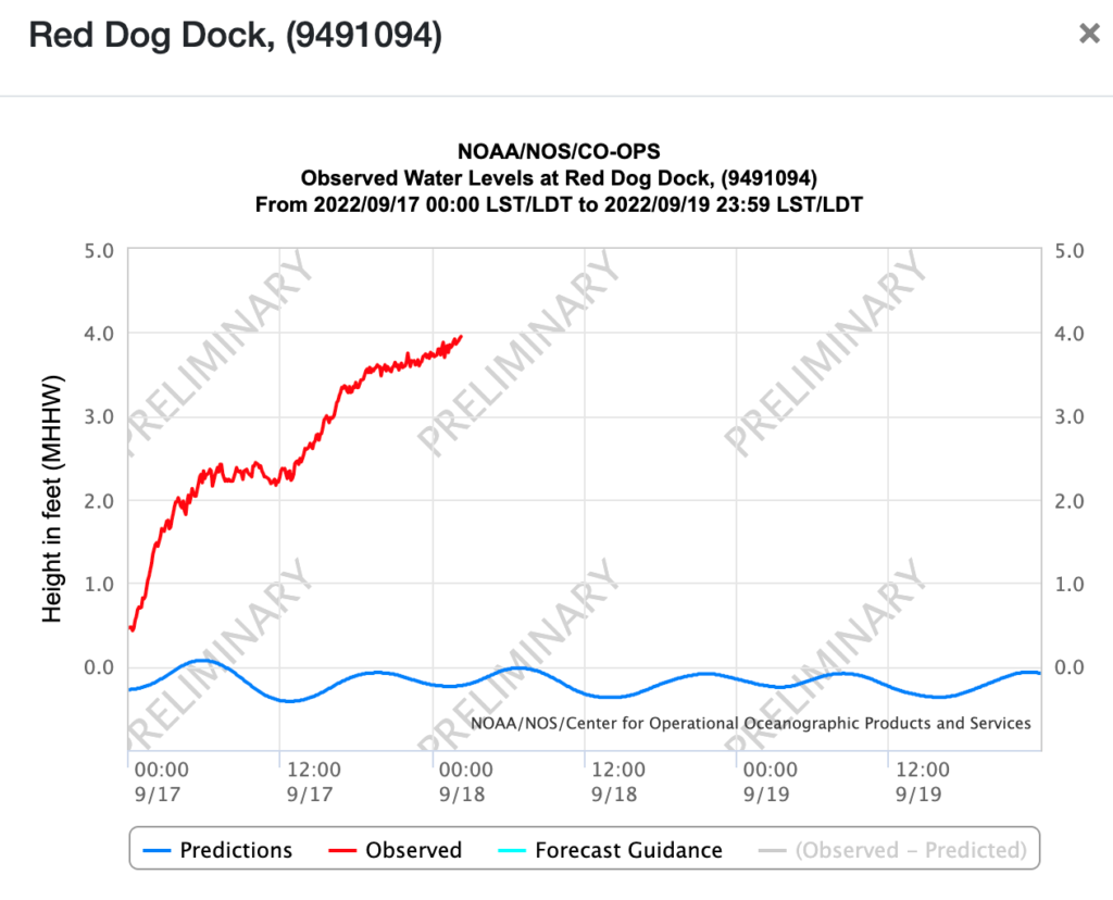
Water still rising in the early morning of Sep. 18 at Red Dog Rock near Kivalina (red line is observed water level, blue line is normal tide level). Source: NOAA https://tidesandcurrents.noaa.gov/
We use cookies to ensure that we give you the best experience on our website. If you continue to use this site we will assume that you are happy with it.AcceptPrivacy policy