Home > Blog > Anchorage: Snowiest December in over 60 years
Anchorage: Snowiest December in over 60 years
December 17, 2022
Anchorage has been pummelled by a series of storms that brought near record amounts of snow to the city and surrounding areas. Over the course of about two weeks, three major storm systems moved through Southcentral Alaska. The first system brought an impressive 15-30’’ of snow to the Anchorage region on December 6-7. Two more rounds of snow soon followed on December 11-12 and December 14-15. The snow had severe impacts on traffic and other aspects of daily life. Schools in Anchorage and Mat-Su repeatedly closed or switched to distance learning due to the treacherous road conditions, as did some state offices and the UAA campus.
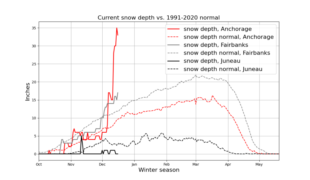
Snow depth through December 16 2022, compared to the 1991-2020 climate normal. Three storm systems brought near record snow fall in Anchorage over approximately the last two weeks.
Local observers essential for snow fall measurements
There was considerable variation in snow fall across and in the vicinity of the city. Many volunteer weather observers entered their snow observations in the CoCoRaHS network during the storm cycles. CoCoRaHS (Community Collaborative Rain, Hail & Snow Network) is a citizen science platform supported by NOAA and the NSF. The aim of the network is to improve the near real time observation density of rain, hail, and snow fall. Solid precipitation can be tricky to measure automatically and weather stations equipped for such measurements are few and far between. Variability in the amount of precipitation at relatively small spatial scales, for example from one side of Anchorage to the other, is usually not captured by weather station data because there simply aren’t enough stations.
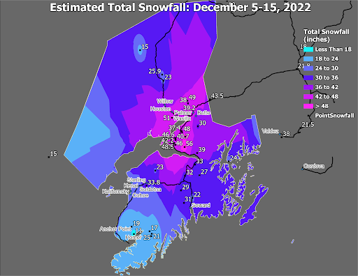
Snow fall map courtesy of NSW Anchorage (David Levin, Douglas Wesley)
CoCoRaHS volunteers can fill this gap and provide a valuable and spatially detailed overview for the National Weather Service, particularly during major weather events like the December snow storms. CoCoRaHS reports are one of a number of data sources that the impacted forecast offices use to generate informational products such as daily snow fall maps (example shown above).
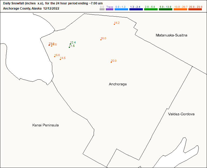
CoCoRaHS volunteer reports of snow fall on December 12, 2022. Measurements by local observers show snow fall variability at high resolution.
Near record snow fall amounts at Anchorage Airport
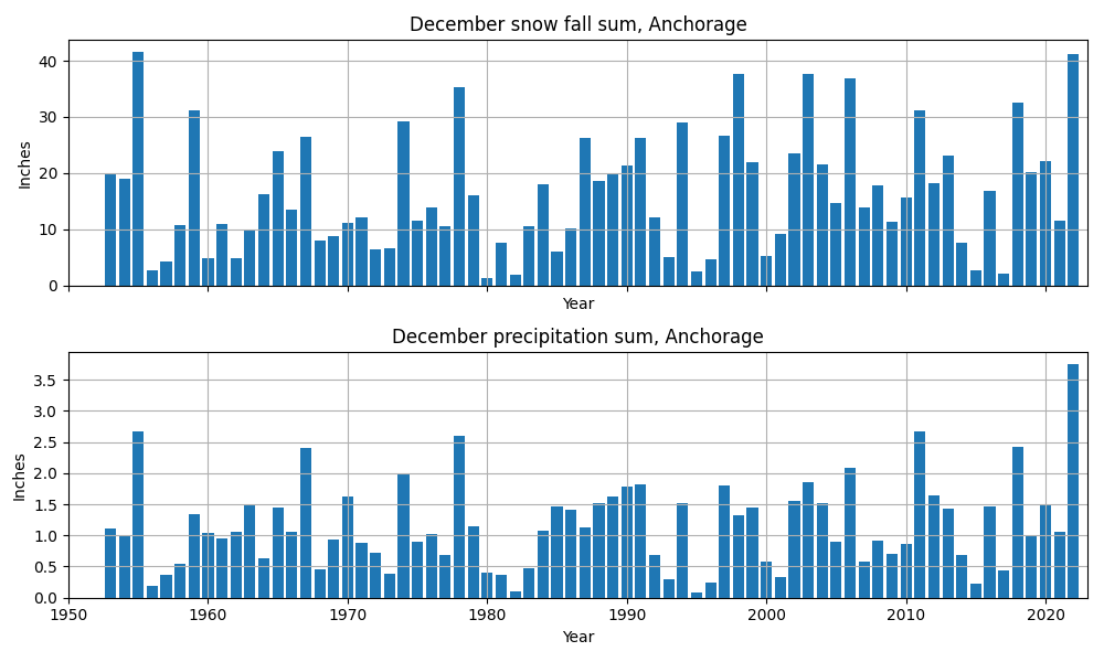
During events like the December 2022 storm series in Anchorage, we often wonder how unusual the weather we are experiencing really is. This is where long time series of meteorological observations are invaluable. The weather station at Anchorage Airport is the only nearby station with snow records going back far enough for climatological analyses.
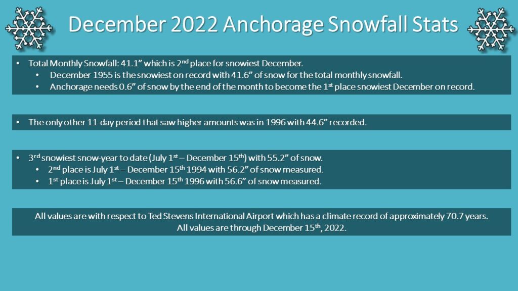
Only December 1955 saw more snow fall than December 2022. December 2022 isn’t over yet, so there is a chance the all time record for the month will still be broken. When considering the monthly precipitation sum, i.e. the amount of water you would get if you melted all the snow that fell, December 2022 has already broken the time series record by about an inch. This is not “just” a new record, it’s a new record that leaves all previous Decembers in the metaphorical dust.
Snow fall statistics courtesy of NWS Anchorage
So, why was the precipitation record broken but not the snow fall record? Those two parameters are connected by the density of the snow. In cold conditions, snow is fluffy and has a very low density. When it’s warmer, fresh snow tends to be heavier and more dense. Very fluffy snow gives a greater snow depth, even if the snow water equivalent is the same as for less fluffy snow. The snow storms in Anchorage during the past two weeks were relatively warm and the snow that fell was relatively dense. It likely had a higher snow water equivalent than snow fall during previous record and near record years.
Snow fall sum (top panel) and precipitation sum (bottom panel) at Anchorage airport for every December since 1953. Data source: ACIS.
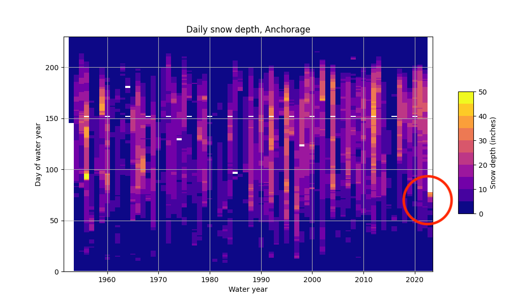
The following plots show the snow depth and precipitation at Anchorage Airport in more detail. In the snow depth plot, the horizontal axis shows the water year (water year 2023 = 2022/2023 season), while the vertical axis shows the day of the water year (i.e., days from October 1st). Bright colors indicate higher snow depths. The plot shows the relatively high year-to-year variability in total snow depths, as well as seasonal patterns. December 2022 stands out from the time series as having very high snow depths much earlier in the winter than usual.
Daily snow depth in Anchorage from the beginning of the time series to December 16, 2022. Red circle indicates December 2022.
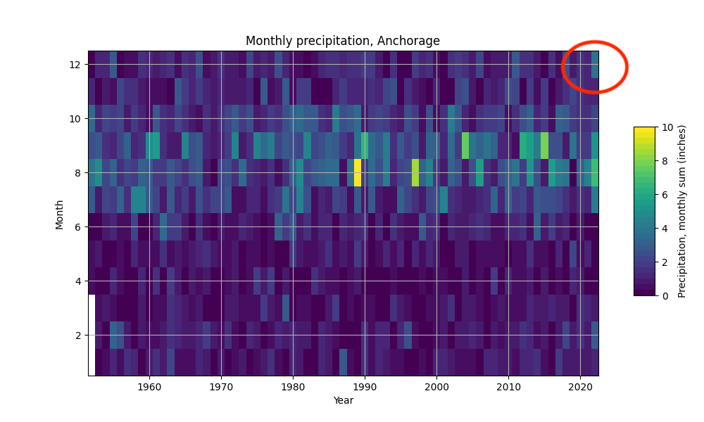
In the plot below, monthly precipitation sums are shown on the vertical axis (1 = January, 12 = December) and calendar years are on the horizontal axis. The plot quite clearly shows the seasonal pattern: Summer is wetter than winter. If we focus on the winter and spring months, the high value for December 2022 (up to Dec. 16) once again stands out. While it wouldn’t seem particularly wet in summer, this amount of precipitation is very unusual during the winter months and represents a new all-time record for December. We’re excited to see what the final tally for December 2022 will be at the end of the year!
Monthly precipitation sums in Anchorage from the beginning of the time series to date. Red circle indicates December 2022.
We use cookies to ensure that we give you the best experience on our website. If you continue to use this site we will assume that you are happy with it.AcceptPrivacy policy