


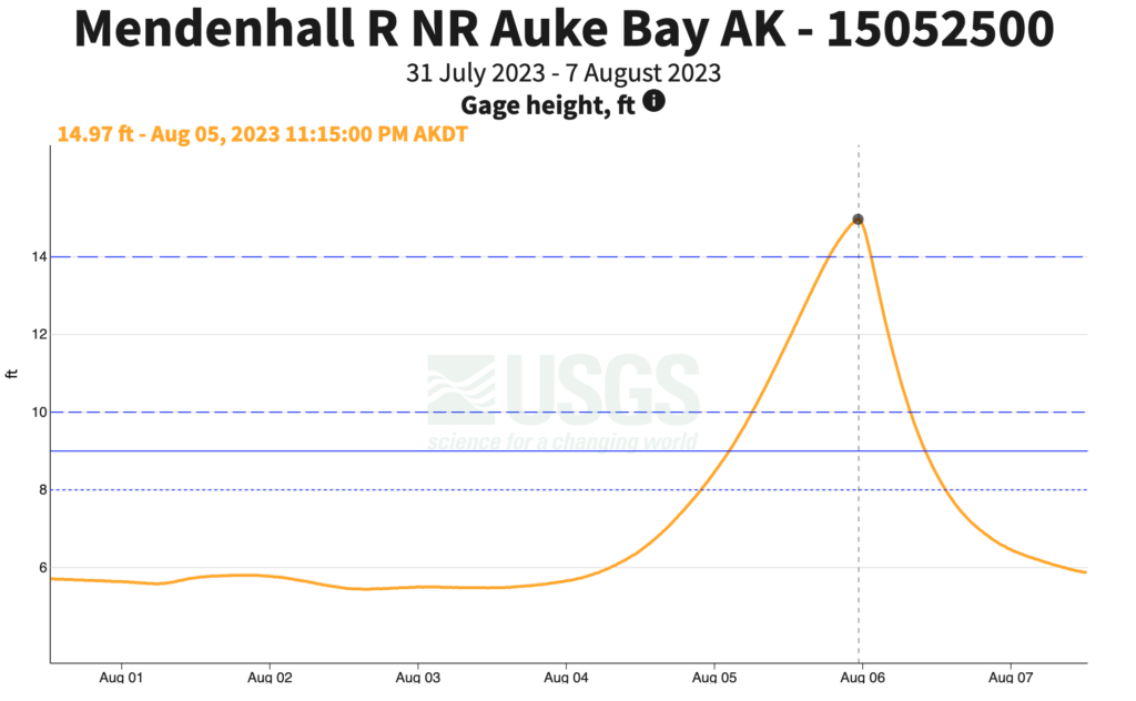
Flooding of Mendenhall River in Juneau destroyed multiple homes this weekend following a glacial lake outburst flood (GLOF) from Suicide Basin at Mendenhall glacier. Mendenhall Lake crested at a record level of 14.97 feet late on August 5.
Suicide Basin has caused annual GLOF’s since 2011, impacting homes and other infrastructure in the Mendenhall Valley. However, this year’s extremely destructive flooding is unprecedented in the 12 year history of Suicide Basin GLOFs.
What is a GLOF?
Glacier lake outburst floods occur when a dam containing a glacial lake fails. The dam may consist of a moraine or of glacier ice. The hydrology and drainage systems involved vary and the flood-producing water bodies may be sub-glacial or marginal lakes. Suicide Basin is a side valley of Mendenhall Glacier. The valley contains Suicide Glacier, a tributary glacier which is no longer connected to the main branch of Mendenhall Glacier. As the tributary glacier receded, a lake formed in a topographic depression in the newly ice-free basin bordering on the main branch of Mendenhall Glacier. This basin periodically drains, causing inundations downstream.
Due to the complex hydrological processes and rapidly changing state of the glaciers, the timing and magnitude of GLOFs are hard to predict exactly. Suicide Basin is the site of ongoing monitoring efforts and research by University of Alaska scientists to improve our understanding of GLOFs in general and the processes leading to the Suicide Basin GLOF specifically. For more information on the Suicide Basin GLOFs, see this story map by AK CASC or this research paper detailing how the glacier recession contributes to GLOFs.
The video below shows a time lapse of the lake in Suicide Basin over the last few days. The terminus of Suicide Glacier can be seen above the rock face in the center of the view. The water that rapidly drains from the lake in the time lapse subsequently made its way down Mendenhall River, causing severe infrastructure damage. This imagery is routinely collected by cameras installed in Suicide Basin as part of the NWS/USGS/AK CASC GLOF monitoring program. See here for current updates and more information.